
Overview
Aerial resource exploration uses aircraft equipped with specialized sensors — including magnetometers, gravimeters, and hyperspectral or LiDAR imaging systems — to survey land from the air in search of mineral deposits, oil and gas reserves, or groundwater. This approach lets exploration companies cover vast, often remote areas far faster than ground-based survey teams, narrowing down promising sites before committing to more expensive ground drilling or sampling. Fixed-wing aircraft typically handle large-scale regional surveys, flying long, closely spaced parallel lines at low altitude to build up a detailed geophysical map, while helicopters handle more localized surveys over difficult terrain. The technique has been standard practice in the mining and petroleum industries since the mid-20th century and remains a key first step in most modern resource exploration campaigns.
History
Aerial geophysical survey techniques for resource exploration developed rapidly after World War II, as magnetometers and other sensors originally developed for military submarine detection were adapted for mineral and petroleum exploration. The mining and petroleum industries adopted aerial survey as standard practice by the 1950s and 1960s, since it let companies screen vast areas for promising sites far faster than ground-based exploration teams. Advances in GPS positioning, hyperspectral imaging, and LiDAR since the 1990s have significantly improved the precision and detail of aerial resource surveys, letting exploration teams narrow down drilling targets with much greater confidence than earlier techniques allowed.
Design & Specifications
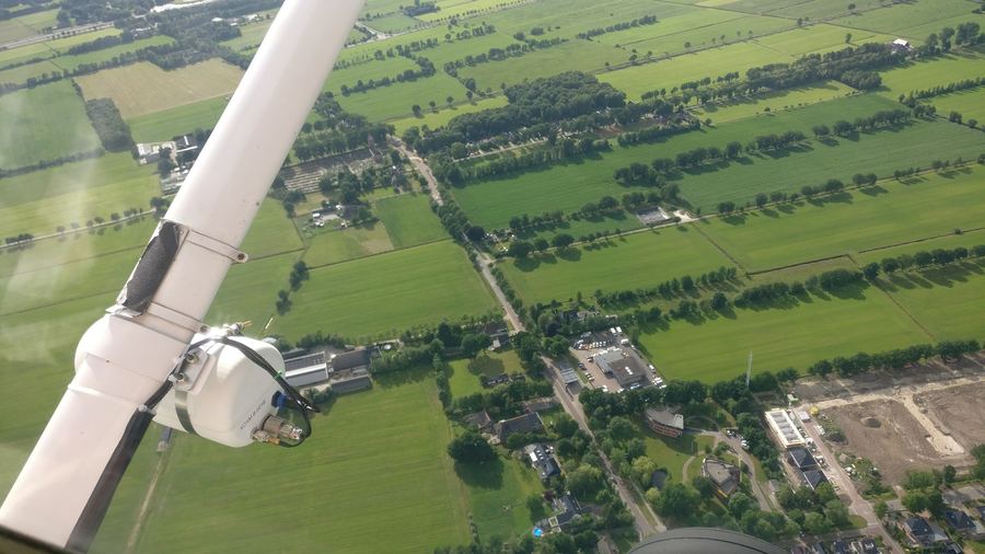
Survey aircraft are fitted with specialized sensor pods, often mounted on a wingtip boom or towed behind the aircraft to keep magnetically sensitive instruments away from the aircraft's own metal structure. Gravimeters, used to detect subtle gravitational variations that can indicate subsurface deposits, require highly stabilized mounting to filter out the aircraft's own vibration. Modern survey aircraft increasingly combine multiple sensor types on a single flight, simultaneously collecting magnetic, gravimetric, and LiDAR data. Data recording systems continuously log sensor readings alongside precise GPS position, letting analysts later map exactly which readings correspond to which ground location.
Operations
A typical survey involves the aircraft flying a tightly spaced grid pattern over the target area, with flight lines close enough together to ensure continuous sensor coverage without gaps. Flight altitude and speed are held as constant as possible throughout, since variations can distort readings and complicate later interpretation. Missions are typically flown in coordination with a ground-based geophysicist who reviews incoming data in near real time to confirm quality and occasionally adjust the flight plan. Once collection is complete, specialists process the results to identify promising sites for more detailed, expensive ground-based exploration.
References
| Category | Special Operations & General Aviation |
| Type | Aerial geophysical survey |
| Platform | Fixed-wing / helicopter |
| Sensors Used | Magnetometer, gravimeter, LiDAR |
| Industry | Mining, petroleum |